The transportation plan for East Solano – more options for everyone
The East Solano Plan proposes building a walkable, mixed-use community located in East Solano County, between the Bay Area and Sacramento. The new community will provide tens of thousands of good-paying jobs for Solano residents, along with tens of thousands of much-needed new homes.
The transportation system is a critical part of this vision. Our goal is to help solve some of the transportation problems that have long affected Solano County, while expanding the set of choices available to people.
We think about transportation in two ways – internal (within the new community) and external (connecting to other places).
Our key priorities are to:
Have a remarkably high share of internal trips that are made on foot, bike, and transit
Lower the cost of living for residents by reducing how much they need to spend
on transportation
Reduce traffic in the region by locating lots of good jobs in Solano County, helping to make highway improvements, and offering a high-quality rapid shuttle service
Create new or improved rail connections for passenger rail, freight rail, or both
We can build internal transportation and operate shuttles on our own timeline, but big moves to improve highways or add rail connections require working together with other communities in Northern California in a way that helps the rest of the region.
A new community in the center of the Northern California Megaregion

Increasingly, the region from Sacramento to San Jose functions as a single area for employment and commerce – the Northern California megaregion.
Today, this megaregion has an imbalance in where people live and where they work. Most of the jobs are located at the edges of this region – either in Sacramento, or in the employment peninsula between San Francisco and San Jose. Meanwhile, a lot of people live in the middle of the region, in places like Solano County, east Contra Costa County, and San Joaquin County. To get to jobs, those people then drive long distances. This dynamic – of Solano County being a bedroom community – is exactly why a recent report ranked the Vallejo-Fairfield area as having the worst commute not just in California, but in the entire country.
There is only one way to fix this: by bringing jobs to Solano County. The East Solano Plan creates an opportunity to help improve the balance of jobs and homes across Northern California. By bringing jobs closer to where many people live today, the plan can reduce traffic and pollution by cutting commute times for many of these workers. Rather than a long trip on congested roads to the Bay Area or Sacramento, Solano residents could have a much shorter trip.
Driving to a job in East Solano takes about 15 minutes from Fairfield, Suisun City, or Rio Vista; and 30 minutes or less from Benicia, Vallejo, or Dixon. For most of these trips, people would be able to travel in a reverse commute direction, where there’s plenty of free capacity on the roads, both in the morning and in the evening. By changing those people’s commutes, this would help take cars off the I-80 during peak congestion.
![]()
The megaregion will continue to grow in the decades to come. If we continue business as usual, the majority of that growth will happen as car-dependent subdivisions, without jobs, on the fringes of the megaregion, with an outsized per capita environmental footprint. The East Solano Plan focuses that growth right in the middle of everything, and then requires that the housing growth is matched with job growth through the unprecedented Solano Jobs Guarantee. Under this guarantee, the new community is required to create at least 15,000 new jobs that pay at least 125% of Solano’s average weekly wage by the time it reaches the first 50,000 residents. By matching housing growth with job growth, and locating it all in the center of the megaregion, we have an opportunity to reduce commuting for everyone.
The internal transportation plan
The plan for transportation within the new community is intended to make daily life more convenient and fun by minimizing time spent in traffic.
Compact form. The transportation plan starts with a compact urban form. Why? Because putting things close together inherently means you don’t have to spend as much time getting from A to B. Getting land use right is the single most important thing we can do to make transportation work.
In addition to compact form, the plan focuses on the details of making the city good for walking: small lots with many different buildings to look at, abundant trees, awnings for rain and sun along shopping streets, frequent small parks, locating schools near local shopping streets so parents can pick up their kids and then do their daily shopping on the same trip, and much more.
Complete neighborhoods. Each neighborhood will have everything you need for daily life: grocery stores and cafes, bars and restaurants, schools and libraries, parks and playgrounds. Planning for mixed uses in this way is important for reducing traffic because it means people can easily walk to many of the things they need most often rather than having to get in the car for every little thing. It’s still easy to get anywhere in the city – for work, to see friends, or just for fun – but for daily errands, the convenience of so many things close at hand will be part of an incredible quality of life.
![]()
Boulevards distribute traffic around the edge. One goal is to minimize the amount of driving through neighborhoods. The plan proposes a Northern Boulevard at the northern and eastern edge of the site to, along with Highways 12 and 113, distribute traffic across the community without going through neighborhoods.
![]()
A hyper-connected street network. The city grid contains a hybrid between traditional American street grids where every street connects through, and “superblocks” (a term borrowed from Barcelona and Tokyo), which have more intimate spaces on their interior.
We rely on the efficiency of the grid to distribute traffic rather than funneling it onto arterials. Inside the superblocks, the “community” streets function more like public spaces, which do accommodate cars, but only driving slowly, under 10 miles per hour.
![]()
All streets are great public places. We are proposing something ambitious: that all streets for cars are also calm and comfortable for people. Most of the streets have no more than one travel lane per direction for cars so we can keep all streets relatively narrow, easy to cross, and great for walking.

Great biking. Every single street in the community is designed to accommodate biking for all ages and experience levels. No one would have ever guessed that Davis, right next door, would have the highest rate of bicycling in America. Davis successfully created a place where biking is a popular, safe, and beloved way to get around, and where over 20% of workers commute by bike, and 19% of all trips are by bike (California Household Travel Survey, 2012). We aim to do at least as well.
![]()


Shared streets are spaces designed for very slow movement where people on foot, bicycle, and cars can safely coexist – a place where a parent might be happy for a child to walk, bike, and play, with adults or even alone. Source: Woonerf Badstraat Gronngue 3 © RdA Suisse, CC 2.0.
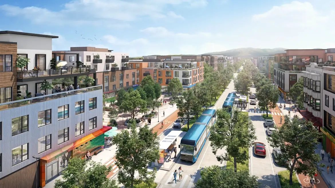
A grid of Bus Rapid Transit (BRT) lines. The public transit proposal is simple: a grid of at-grade, center running, physically separated transit lines, spaced one half mile apart. This system is a version of what planners call “bus rapid transit” that was first deployed at scale in Curitiba, Brazil in 1974 and since adopted all over the world as a cost-effective approach to public transit. Running in physically separated lanes means transit is never caught in traffic. Add in transit priority at traffic signals and prepaid, all-door boarding, and you have a recipe for a fast, frequent, reliable, and cost effective transit service.
Car sharing. We are going to operate a big car sharing program, making a variety of cars, trucks, and vans available to people when they need them without the overhead of vehicle ownership. The way it works is simple: you reserve a car on your phone, then pay for it based on how long you have it and how far you drive. Extensive car sharing enables a lot of households to get by with one fewer car, and is one of many ways to make living here more affordable.
Transit lines terminating at parking garages. The idea of putting parking at the edge of a community is not new – Venice, Italy is one well-known example. The idea of a grid of transit is not new either – most transit planners consider it to be a best practice. The East Solano Plan plan puts these pieces together to have transit lines terminate in a parking garage at the edge of the community. We are making it intuitive to park at the edge of the city and then get an easy transfer into the core, although we still accommodate cars gracefully throughout the new community.
The external transportation plan
Our top priority is to make it easy to get to and from the new community, while minimizing the impact on everyone else – and ideally, actually improving the broader transportation system in Northern California. If we do this right, we can be a big help in stitching together the Northern California megaregion, improving connections between Sacramento, the Bay Area, and the Central Valley.
To restate a key point: the first step is bringing good-paying jobs and a full range of services to the community, which will minimize the number of trips people need to take on highways outside the new city. Some people can live and work within the same community. And some people working from home some of the time will also reduce overall traffic.
Additionally, some people who currently live in Solano County and have to drive west on I-80 to the inner Bay Area would have a much shorter commute to the new community. In the case of Vallejo or Benicia residents, this commute would also be in the reverse direction, utilizing spare capacity on existing highways. Those shorter trips are great for people who work in the new community, and they're great for everyone else by removing peak period trips from I-80. The same thing applies to anyone traveling to the new community for work on Highway 12 from Vallejo, Benicia, Suisun City, and Fairfield – all of those trips are in reverse commute direction, where there is currently underutilized capacity.
The same thinking applies to grocery stores, health care, and all the other needs of daily life: making sure people don’t need to travel out on a highway to access these services is the first and best way to minimize impacts on traffic. Having the option to get things close at hand will be a huge benefit.
We will operate a high quality rapid shuttle program to other communities. To give people options and get as many cars off the road as possible, we intend to offer a high quality shuttle system that is an attractive alternative to driving. We intend to connect with the following destinations:
Travis Air Force Base and UC Davis – outside of employers who are located directly in our community, these are likely to the be the two largest employers for our residents
Other cities in Solano County
Capitol Corridor, BART, and the Vallejo Ferry Terminal
Employment centers in Sacramento, the East Bay, and San Francisco
As the population of the new community grows, the destinations and the frequencies will increase. We should be able to achieve quite a high share of trips being taken on public transit.
The downtown will be anchored by a major transit center. This will be a transit center that brings together rapid shuttle connections from all destinations. It will be designed to accommodate future rail connections (more on this below).

We will work to add dedicated transit lanes to the highway network. Whether within the community or on its way to/from I-80, we want to make sure that transit is never stuck in congestion to make it as competitive and attractive as possible. Transit only lanes can also be used for emergency vehicles, and by trucks carrying cargo to Travis Air Force Base (which are often stuck in traffic today).

Accelerate upgrades to Highways 12, 113, and Interstate 80. As a state we have wisely chosen to be very judicious when expanding highways, but we cannot encase California in amber as it is in 2024 – there are wise ways to grow, and some targeted highway improvements are sensible.
We are keenly interested in accelerating long-awaited improvements to Highways 12, 113, and Interstate 80, and believe the East Solano Plan can act as a financial and political catalyst to make these projects happen as soon as possible. Those are Caltrans facilities, but we can work with the rest of Solano County to partner with Caltrans, Solano Transportation Authority (STA), and Metropolitan Transportation Commission to expedite design, approval, funding, and construction.
These improvements have in some cases already been studied by public agencies. To name just three examples:
CalTrans, STA, and Rio Vista studied building a new bridge/tunnel and re-aligning Highway 12 north or south of Rio Vista (here, and here). A study by Fehr & Peers found that most trips on this section of 12 are through traffic, where cars do not stop in Rio Vista.
CalTrans and SA studied expansion options for Highway 113, including a possible bypass of Dixon. The preference for a bypass of Dixon is embodied in Dixon’s 2040 general plan under policy M-6.A “Work with Caltrans to study options for re-rerouting SR 113 away from Downtown Dixon.”
As part of the I-80I/I-680-SR-12 Interchange project, CalTrans and STA studied and permitted a number of improvements, including widening I-80 between I-680 and Highway 12 and turning Highway 12 into a grade-separated highway (three lanes in each direction) between I-80 and Suisun City.
These are long-term projects that will require coordination between multiple agencies. However, we believe that since the East Solano Plan addresses many of the issues that are priorities for regional, state, and federal governments (including housing affordability, job creation, sustainability, and climate change), and since the East Solano Plan will generate hundreds of millions in new taxes at all levels of government, there are pathways to getting these improvements funded and built.
Over the long run, work to connect up to the Northern California rail network. In the short-term, we will support efforts to enhance Capitol Corridor service, and are exploring how to bring freight rail service to East Solano. In the longer run, we are also committed to working with county, regional, state, and federal agencies on options for bringing rail to the new community, as part of a broader upgrade to the Northern California rail network. This new community can be a node on a system that generates high ridership because of its compact form and its ability to get everyone to a central transit station. We are designing the new community to be "rail ready" – ensuring the right of way exists for rail through the community as well as for a central station – and will do whatever we can to make it happen. We are looking forward to working arm in arm with leaders in the Bay Area and Sacramento to expand the regional rail system and other offerings so that we can together make public transit a viable option for more people more of the time.
Summing it up
The East Solano Plan proposes to build a medium-density, compact community, and several ways to connect it to the rest of Northern California.
We can get started with existing infrastructure, and grow up to a point. After that we need to add more infrastructure, starting with a transit lane that will allow rapid shuttles to utilize the region’s managed lane network on freeways.
In the short- and medium-term, the new community’s public transit system will rely on shuttles. We have a plan to run what will become one of the biggest transit operations in Northern California, utilizing managed lanes for buses on freeways, and supercharging all of it with a set of land use policies that make the new community the most transit-oriented community in California alongside San Francisco.
In the long run, our goal is to join the rail network – to build a connection to the rest of Northern California via rail.
The East Solano Plan accommodates large numbers of people in a way that minimizes the development footprint while achieving far higher rates of walking, biking, and public transit use than places where most growth is otherwise going (which is mostly car-dependent subdivisions, some in California, and most in Arizona, Texas, and Florida). We are confident the environmental analysis that will be conducted as part of the Environmental Impact Report will show that people here will generate the lowest per capita greenhouse emissions in California, and certainly less than those living in other states.
As part of the state’s required environmental review process, we will answer this question definitively – we will conduct a rigorous, peer-reviewed assessment of the projected rates of driving per person, compared to other parts of the Bay Area as well as growth in other parts of California. We believe that it will show that building this community leads to lower environmental impact than not building it.
Finally, it’s important to remember that this new community is also a response to an urgent problem: California has a deficit of millions of homes, which has caused the median price of a California home to rise to over $900,000 – more than 9 times the state’s median household income. There is simply no credible path to meeting the state’s housing needs without new strategies at the scale of what the East Solano Plan is trying to do. If we want to prevent millions of people being forced out of the state, and others into homelessness, we think it’s clear that we need more tools in the toolbox – ways to add new compact cities rather than only work within the ones that existed 100 years ago.
The East Solano Plan will improve commutes in Solano County in the short and medium run, and set up the region for better connectivity in the long run.